Tuesday, 20 November 2018

KERIKERI: THE BIRTHPLACE OF NEW ZEALAND WINE

When Samuel Marsden planted the country’s first vines at Kerikeri 200 ago, he prophesied that winemaking would become important in the area. His prediction was certainly correct; the Kerikeri area is home to several great vineyards.
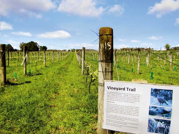
Whelan_11-Vineyard-Trail,-Ake-Ake-Vineyard.jpg

NEW ZEALAND’S FIRST VINEYARDS

Samuel, New Zealand’s first missionary, established a vineyard with more than 100 varieties of grapes at the mission settlement he founded at Kerikeri. He wrote in his journal of 1819 that he thought New Zealand’s climate and soils should be ‘favourable to the vine’.
British Consul, James Busby, arrived in the Bay of Islands in the 1830s. James was a wine expert, having trained in viticulture in France. His skills had already started the Australian wine growing industry. He had published books outlining directions for planting vineyards and making wine.
James lost no time in following in Samuel’s footsteps and was soon producing vintages at Waitangi. The French explorer Dumont d’Urville described one of James’ wines as ‘a light white wine... sparkling and delicious’. It has been suggested that this was chardonnay, James’ favourite tipple.

KERIKERI’S MOTORHOME-FRIENDLY VINEYARD

Alt TEXT HERE
Wine barrels outside the restaurant at Ake Ake
I had the same sort of thoughts while tasting some of Ake Ake Vineyard’s white wines at their cellar door. Tucked off the road to Waimate North (where Charles Darwin saw vines growing at the mission back in 1835), Ake Ake Vineyard and restaurant is well worth seeking out.
After sampling the chardonnay and pinot gris, I tried the pinot grigio, and decided that was the one for me. Meanwhile, Malcolm was trying the reds, finally choosing a bottle of chambourcin, made from red grapes that grow well in Northland. Then we were tempted by the port, which tasted like liquid Christmas cake—perfect for winter nights.
Alt TEXT HERE
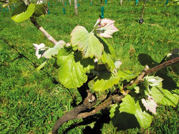
New vines growing at Ake Ake Vineyard
Hosts John and Aynsley Quenault purchased Ake Ake in 2004 and since then have been developing the boutique winery. John hails from the Channel Islands where his family had been wine merchants for five generations, while Aynsley is a New Zealander who spent a lot of time travelling by campervan on her OE.
The couple knew little about running a vineyard back in 2004 but researched winemaking at their local library and were soon winning medals with their vintages.
A few years ago, John and Aynsley decided to convert the vineyard to organic grape growing. They no longer use sprays, which means it is perfectly safe to immerse yourself among the vines on the vineyard trail.
Alt TEXT HERE
Special deals at the Kerikeri Old Packhouse Market
This is a self-guided walk that meanders along the rows of grapes, with signboards giving information along the way. We learned about the grape varieties, the winemaking process, and about all the creatures that call the vineyard home.
Ake Ake also has a restaurant, open for lunch and dinner, and locally sourced vegetables, meat, and seafood. During summer, meals are served on the deck outside, while in winter, diners can be eaten inside the cosy bistro.
The best thing of all, though, is that motorhomes are welcome overnight. Diners, or those purchasing wine from the vineyard, can stay in the parking area or make their way to a grassy paddock, where parking comes with views across rows of vines and nothing but rabbits, quail, pheasants, and the odd hedgehog for company.

Where else to find wine in Kerikeri
Alt TEXT HERE
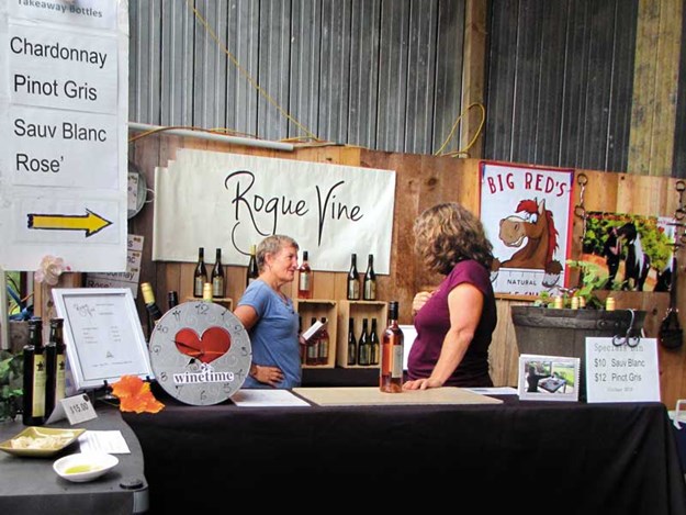
Wine for sale at the Old Packhouse Market
There are several other vineyards in the Kerikeri area, though none of the others offer overnight parking. However, Cottle Hill Vineyard is within easy walking distance of the Wagon Train RV Park. Cottle Hill is situated on the highest point in the area, so visitors can sit on the deck and admire beautiful views while enjoying their wine.
Another great wine tasting experience is at Kerikeri’s Old Packhouse Market, held every Saturday. Several local vineyards sell their produce here, and it’s an excellent place to sample wine as well as cheeses, bread, and pastries.
Alt TEXT HERE
The view from Cottle Hill Winery
We are always tempted by something when we visit here and often end up grabbing coffee and cake while listening to live music before heading back to the motorhome with our purchases. The NZMCA park at Rainbow Falls is a convenient place to stay.

Friday, 24 August 2018

Destination Dargaville

This is my latest article in Caravans, Motorhomes and Destinations Magazine


Dargaville sits on the banks of the Northern Wairoa River, close to kauri forests, the golden sands of Ripiro Beach, and the inlets and bays of the Kaipara Harbour, making it an ideal base for exploring.

The promise of some sunny winter days lured us to this small town on Northland’s west coast. The NZMCA recently opened a park at the old Thompson’s boatyard site beside the river and within easy walking distance of the town centre. As we pulled in, we noticed two interesting, old boat-builder’s sheds. These sheds date back to Dargaville’s early days and were used to build whaleboats that the explorer Ernest Shackleton took to Antarctica.
Ernest’s thank-you letter, displayed in Dargaville Museum, praises the craftsmanship of the boats.
Untitled-1.jpg

A brief history

Dargaville’s history is closely bound to the river. When the area was thickly forested, water transport provided the means to get from place to place. Later, as the forests began to be felled, kauri logs were loaded onto ships at Dargaville. The riverbanks still have many jetties and piles for boats to tie to, and there is a small boat harbour.
Politician and timber merchant Joseph Dargaville founded the town in 1872.
He realised the potential of the area and built a timber mill and trading post. Before long, he had added docks and tramways. Wanting to establish a town, rather than a bush settlement, he built shops and a church. Settlers began to flock in. The Central Hotel was established during this logging and ship building era, later advertising that it was close to the wharf and railway, and that telegrams were promptly attended to. The hotel still stands proudly by the river, its white paintwork gleaming as we strolled past.
After the kauri forests were felled, gum-diggers from Dalmatia settled in the area. Their heritage is celebrated by a statue in the town centre and also through exhibits and information at the Dargaville Museum. This is well worth a visit. As well as pioneering and gum-digging history, there is a maritime exhibition hall that showcases relics of ships wrecked on the Kaipara bar, and a Maori hall where there is a pre-European, 16-metre-long canoe hull, uncovered from the sands of the Pouto Peninsula.

KAURI COAST

It is ironic that the kauri, once felled in their thousands, are now treasured icons. Waipoua Forest, home to Tane Mahuta and other giant kauri trees, is around an hour’s drive north of Dargaville but closer is Trounson Kauri Park. James Trounson made the area a park in 1890. Since then, the park has expanded to 586 hectares and is a mainland island, home to not only kauri and other native trees but also kauri snails, bats, and brown kiwi.
The track at Trounson was a 40-minute loop, mostly on boardwalk, which helps protect the tree roots and prevent kauri die-back. Unfortunately, several of these marvellous trees have succumbed to the disease, though others towered above us. The bush was deep and green, full of spiky kiekie, neinei, and curling ferns, through which we heard the calling of tui.
Back on the main road, we called into Nelson’s Kaihu Kauri, a gallery of all things kauri.
Outside there was a large collection of swamp kauri logs and inside, an array of wooden arts and crafts, furniture, and kauri gum products. The gallery’s centrepiece is a 30-tonne kauri log dug from nearby peat swamps.
Untitled-1.jpg

Ripiro Beach

As a contrast to kauri forests, we turned towards the coast. Ripiro Beach, at 101km, is the longest drivable beach in New Zealand, stretching from Manganui Bluff to Pouto. It can be accessed at several places. Last time we were in Dargaville, we walked along the beach, leaving from Kai Iwi Lakes and going as far as Maunganui Bluff. This time, we went to
Baylys Beach, driving through the seaside settlement and onto the beach.
White sand stretched as far as the eye could see in both directions. High dunes bordered the beach, some had darker layers protruding. This was lignite, containing embedded kauri logs that were buried under the sand around 60,000 years ago. There were few people in the empty landscape and just one patient fisherman standing ankle-deep in the sea.We took a loop road inland to Mahuta Gap, south of Dargaville. This entrance to the beach was between massive sand dunes and is only suitable for four-wheel drive vehicles. We drove steeply downhill before coming to what was more stream than road. This section of beach was similar to Baylys but was wilder and seemed more remote. Finally, we came to Glinks Gully, another holiday settlement with quite a few baches—some traditional, others more modern.
Untitled-1.jpg
We then headed to the Pouto Peninsula, a 55km strip of mainly sand dunes that stretches from Dargaville to Pouto at the mouth of the Kaipara Harbour. It is quite narrow, varying from 4.5 to 14km in width, though the dunes are around 100 metres high, with the highest being more than 200 metres above sea level. From the road, we
could see down to the Northern
Wairoa River and across to the pyramid-shaped Tokatoka and the huge Maungaraho Rock.

GIANT KUMARA

Not all of the land surrounding Dargaville is sand; the area is known as New Zealand’s kumara-growing capital. As we drove back towards Dargaville, we saw a giant kumara at the roadside.
It was advertising the Kumara Box—an unusual attraction. Here, visitors can watch a show and learn everything there is to know about the vegetable. There is also a ‘train’ ride—a tractor towing brightly coloured carriages, made from oil-drums, around the farm.
Unfortunately, bookings are essential for the Kumara Box, so we had to pass on this occasion.
Dargaville Rail Tours is another unusual attraction. Trips in converted, self-drive golf carts leave from the town and, using the tracks of the old railway, pass through farmland to Tangowahine. A longer journey goes to Waiotira junction, taking between seven and eight hours (return). The same company runs 90-minute boat trips in a flat-bottomed boat called Daisy.
Kaipara Cruises occasionally host river trips in the harbour, leaving from Helensville, Dargaville, or Pahi. We took the Kewpie Too on a trip down the river from Dargaville to Pouto a couple of years ago. The commentary told us about the history and geography of the district before we disembarked at Pouto. From here, the tour was by bus to Pouto lighthouse, which was surprisingly small but atop a very steep sand dune.
For a small town, Dargaville has a lot to see and do. We’ll be back.
Untitled-1.jpg

TRAVEL INFORMATION

  • The NZMCA park is at 1 River Road, Dargaville, just across the Kaihu River bridge. There are several other motor camps, campervan parks, and Park Over Properties in Dargaville. Campervan sites are also available at the Dargaville Museum.
  • Dargaville Museum is at Harding Park. Hours: November–March 9am–5pm, April–October 9am–4pm. Find out more at dargavillemuseum.co.nz.
  • Trounson Park is off SH 12, 40km north of Dargaville. The easy loop walk takes 40 minutes. More information can be found on the DOC website. doc.govt.nz.
  • Nelson’s Kaihu Kauri is on SH 12 at Kaihu. Hours: 9am–5pm Monday–Saturday. Visit nelsonskaihukauri.co.nz.
  • The Kumara Box is at 503, Pouto Rd, Dargaville, kumarabox.co.nz.
  • Information about Dargaville Rail and River Tours can be found at portdargavillecruises.co.nz. Kaipara Cruises has more info at kaiparacruises.co.nz.

Saturday, 14 July 2018

Voyage of the Ika Roa


In Voyage of the Ika Roa, Heather Whelan relates the story of how she and then husband Tim built a boat and sailed it from England to New Zealand.  The couple had no boat-building or sailing experience but they set to and built Ika Roa, a catamaran.  Once afloat, their voyage took them to Spain and Portugal, then across the Atlantic.  By the time they arrived in the Caribbean, they were seasoned sailors.  While cruising the Pacific Heather became fascinated by Polynesian history and the islanders way of life.  Friendships among the cruising community and with locals enriched the journey.

NZ$ 29.99 plus postage ($5.50 within New Zealand)
>
If the buy now button doesn't work you can buy direct from me:  heatherwhelan2@gmail.com

Friday, 6 July 2018

Book Launch


Book Launch

Whangarei Library - July 14th, 10.00 am

Voyage of the Ika Roa is a travel memoir about building a catamaran and sailing from England to New Zealand.

Weekend getaway

MCD travel writer Heather Whelan heads to the winterless north for a wander through Kerikeri

Kerikeri is our favourite place for a weekend break. We usually stay at the NZMCA park at Rainbow Falls: a great location, not too far from the town centre but with a rural vibe.


Kerikeri -2

The park backs onto an area of native bush and, once over the stile that leads from the campground, you are right beside the Rainbow Falls. The waterfall cascades 27 metres into a pool below.
A walking track goes from the falls to the Kerikeri Basin, home to the Stone Store and Kemp House. There are two good cafes here, well worth checking out. Alternatively, the Rainbow Falls Tea House Cafe is right beside the NZMCA park, and it serves breakfast, lunch, and morning and afternoon tea.
Kerikeri has some great shops to explore, but one thing we never miss is the Saturday market at the Old Packhouse. Here you can buy fruit and vegetables, local cheese, meat, bread, limoncello, and wine.
There are crafts galore, everything from gorgeous gourds to handmade hats. Tables encourage visitors to relax with coffee and cake while listening to live music. The Packhouse also has a Sunday vintage and car boot market, good for a browse.
The NZMCA park can get crowded at times, so if you prefer somewhere quieter, try Aroha Island. Accessed by a causeway, the island is a 12-hectare eco-sanctuary on the Kerikeri Inlet. There are bush walks, and kayaks can be launched into the sheltered tidal waters.
If you take the guided kiwi-spotting night walk, you have a good chance of seeing a North Island Brown Kiwi in its natural habitat. And if you’re feeling the cold, why not stop at Ngawha Springs for a soak on the way home?

Sunday, 3 June 2018

Aorere Goldfields Walk


My Latest article in Wilderness Magazine

Aorere Goldfields Track, Aorere Goldfields Conservation Area


In 1856, a gold rush was sparked in the Aorere Valley when a couple of settlers discovered a small amount of gold. More than two thousand men streamed into the ‘tent city’ of Gibbstown over the next few years and headed up the valley. Seven hotels were quickly built, and such was the expectation of fortune that the bay, previously known as Murderers’ Bay and Massacre Bay, was re-named Golden Bay. Gibbstown was to make way for a city called Collingwood, most of which was never built. 
The Aorere Goldfields Track winds its way through the hillsides where miners worked and there are now remnants from the gold mining era. 
The track first crosses a scrubby area called Druggans Flat and almost immediately passes a large pile of rocks, marked as a ground sluicing claim from the 1880s. From here, the path climbs steadily through manuka scrub. It’s easy walking, being mainly along parts of the original miner’s benched track, with water races (mostly dry) beside the track in some places. There is a marked side track which leads to Stanton’s Creek viewpoint: an area of native bush.
A little further on, another side track leads to Stafford’s Cave, the first of two caves. It has stalactites in the large, semi-open overhang above the entrance. It is possible to explore more of the cave with the right gear. A DOC sign explains the caves were formed more than 500,000 years ago and warns against damaging or removing any of the formations. 
Ballroom Cave is a few minutes further along the main track and is easier to enter. As its name suggests, it was used by miners for dances, although the floor is so uneven it is hard to imagine how. Torches are needed to explore the cave.
The trail then arrives at Druggan’s Dam. Built in 1873 by George Druggan, it was later enlarged by the Slate River Sluicing Company. Although a 4km water race was built, little gold was ever found and the company closed it in the early 1900’s. The track circles around part of the water’s edge then continues past the side of the reservoir. From here, the views along the Aorere Valley and out to Farewell Spit make the climb worthwhile. In the other direction, the Burnett and Wakamarama ranges can be viewed. 
From this high point, the track loops around the hillside, following part of a 4WD track for a while, before joining the original path just below the caves.

Friday, 1 June 2018

Motu Cycle Trails


My Latest article in Motorhomes Caravans & Destinations magazine

The Motu trail, which forms one of the Great Rides on the NZ Cycle Trail, gives riders a chance to experience some of NZ’s most beautiful scenery
Whenever we visit Opotiki, we like to stay at the headquarters of Motu Trails Ltd on St John Street—a few minutes walking distance from the town centre.

Whelan _13-Swingbridge -on -the -Pakihi -Trail
This is a Park Over Property for NZMCA members, which has been convenient when we have used the shuttle service and have had early starts.
There are three cycle trails under the Motu Trails umbrella: the Dunes Trail, which is rated easy; the Motu Road Trail, rated intermediate; and the Pakihi Track for advanced riders.

THE DUNES TRAIL

Whelan _4-On -the -Dunes -Trail
On our first visit, we decided to ride the Dunes Trail that starts just 800 metres along the road from Motu Trails Ltd.
At the end of the road, we left the township and cycled across the Pakowhai ki Otutaopuku Bridge, which opened in 2012. The bridge is a landmark, with brightly painted pou and information panels.
Whelan _11-Pou -at -the -end -of -Motu -Road
When the area around the Otara River saw its first settlement, it was known as Pakowhai but changed its name after Tarawa—an ancestor of local Maori—made landfall, claiming to have swum from Hawaiki with his pet fish. He found a pool for his fish and re-named the place in their honour: O-Potiki mai-Tawhiti, meaning ‘two pets from afar’.
The Dunes Trail was a lovely ride.  It was flat and meandered around and over the dunes for 10km. The track was wide and easy to cycle, which was good because I found it hard to keep my eyes off the view out to sea and along the coast.
Whelan _3-Preparing -to -ride -the -Dunes -Trail
The waters of the Pacific sparkled all the way out to White Island and sandy beaches stretched into the distance, with the rugged cliffs and mountainous interior of East Cape on the horizon.
Before long, we came to Hukuwai where a signboard explained how, in the days gone by, Maori would set nets for the large schools of fish that arrived off this beach. Further on, the trail looped down close to the road beside a toilet block and a freedom camping area.
We vowed to park here on another visit to Opotiki; what could be better than waking up with the sea on your doorstep?
The trail continued, crossing a stream with a guardian pou, before we found ourselves cycling along a wooden boardwalk across the beach.
Finally, we passed behind Tirohanga Beach Motor Camp (which looked like another great place to park up) before terminating at Jackson Road. We retraced our steps a little, finding a quiet beach for a picnic lunch before riding back to Opotiki. The ride took about three hours with plenty of time to stop and enjoy the view and read the information signs.

MOTU ROAD

Whelan _10-Picnic -spot ,-Motu -Road
This one was quite different from the coastal Dunes Trail. It started up in the mountains—an hour’s drive from Opotiki through the Waioeka Gorge—and it was a steep, rough ride down to sea level through bush and farmland.
The Motu Road used to be the main route between Gisborne and Opotiki before the Gorge Road was built, but the road itself wasn’t built until 1918, and it was long after that, the road surface was metalled and bridges were built to replace fords.
More recently, in the 1980s and ’90s, the road has been used as a stage in the Rally of New Zealand. Vehicles still use the road but mostly 4WDs, as it is a rugged drive.
The Waioeka Gorge Road (SH2) may have replaced the Motu Road as the main thoroughfare, but it is a tortuous highway, passing between steep-sided hills.
Whelan _6-Coffee -stop -at -Living -Water -Bush -Cafe -in -the -Waioeka -Gorge
Work started on the road in the 1930s but wasn’t opened until 1962. There were attempts at farming in the 1900s but the land was steep and the soil poor. The cleared areas have reverted to bush and are part of the Waioeka Gorge Scenic Reserve, New Zealand’s largest scenic reserve.
We couldn’t stop to visit the various sites of interest through the gorge but added them to the mental list of ‘things to do next time’. We did stop, however, at the Water Bush Cafe (tucked into a clearing) for coffee and home baking before the driver continued on through Matawhai and Motu to the drop off spot where we unloaded our bikes and set off down the road.
Whelan _9-Navigating -the -ford
It was misty and mysterious high up in the beech-forested hills, but as we descended, we began to get more views. Lower down, we cycled through areas of rainforest where tawa and puriri towered over the canopy.
Eventually, we passed through more open countryside (with one exciting ford to negotiate) before coming out into farmland and eventually arriving at the end of Jackson Road where the Dunes Trail began. We got back to our bus after riding for about five hours.

PAKIHI TRACK

Whelan _12-Start -of -the -Pakihi -Trail
I decided not to tackle the Pakihi Track, so Malcolm went alone. The shuttle dropped him on the Motu Road at the boundary between the Gisborne and Opotiki Districts and, after 17km, he turned onto the Pakihi Track.
Originally formed to drive cattle, the track was abandoned after a few years when the bridge was washed away. The cycle trail is narrow with sharp bends and steep drop-offs, so take extra caution.
Whelan _15-Pakihi -Trail -winds -through -bush
Just past the halfway point, there was a hut (a good lunch spot) and shortly after this, a suspension bridge. The remains of the old bridge could be seen here.
Malcolm particularly enjoyed the next part of the track, which followed a stream with dramatic scenery and stunning views. The last section of the track came out on a quiet rural road leading into Opotiki and he arrived home after about four hours of riding.
Whelan _17-Lush -bush -scenery -on -the -Pakihi -Trail

Further information

  • For more details on the Motu Trails, visit motutrails.co.nz and motucycletrails.com
  • To find out more about Opotiki, visit opotikinz.com and for information about the Waioeka Gorge there is a downloadable brochure, The Waioeka Journey at doc.govt.nz
  • Bike hire and shuttle services are available from Motu Trails, 138 St John St, Opotiki
  • The Motu Road Trail and Pakihi Track are in remote areas with little mobile coverage and no shops, so take adequate food and water and also cycle repair and first aid kits
  • There are several campgrounds and holiday parks in Opotiki and the NZMCA has a park adjacent to Motu Trails Ltd headquarters