Thursday, 30 May 2019

The Winterless North

My latest story in Motorhomes, Caravans & Destinations Magazine

Heather Whelan checks out some great northern spots for motorhomers fleeing the cold

In the USA they call them ‘snowbirds’ – motorhomers who avoid the worst of the winter weather by driving south to Florida. In New Zealand, it is Northland that draws people to overwinter in its subtropical climate.
Alt TEXT HERE
DOC campground, Tapotupotu Bay

Department of Conservation campsites

Whether visiting for a weekend or parking up for an extended period, there are a variety of places to spend time in the winterless north. For those who don’t need the facilities of a holiday park, DOC campsites must be top of the list.
There are 10 in Northland that are accessible to motorhomes. With beachside sites from Kapowairua (Spirits Bay) in the far north to Uretiti Beach south of Whangarei, ocean views are never hard to find.
When we visited Tapotupotu Bay, DOC’s most northerly campground, we loved the sense of being so far from the hustle and bustle of city life. Although it was close to Cape Reinga, the busloads of tourists who visited didn’t stay for long.
It was only those campers who, like us, enjoyed the remoteness of the site and the pristine natural beauty of the area who stayed overnight or longer. For us, one of the attractions of Tapotupotu Bay was the fact it was right on the Te Paki Coastal Track.
Alt TEXT HERE
DOC campground, Tapotupotu Bay
We walked 5km along cliff tops to Sandy Bay and Cape Reinga, admiring the stunning views along the coast. Other campers were enjoying the surf. Matai Bay had a similar, remote vibe. We enjoyed more walks here, but it is also popular with boaties, fishermen and divers.
Uretiti Beach had the advantage of being close to the little town of Waipu. We loved fossicking in the antique and second-hand shops here and spent an hour or so investigating the Waipu Museum.
This told us the story of a tight-knit band of Scots who made their way to Waipu, via Nova Scotia, and settled under the autocratic leadership of their minister, Rev McLeod. 
Bush-lovers can park in DOC’s Northland campgrounds in Trounson Kauri Park, Puketi Forest and Raetea North Side campsites. We found Puketi Forest DOC campground almost deserted when we visited out of season.
Alt TEXT HERE
DOC campsite, Puketi Forest
There were several short walks here that took us right among giant kauri trees. The Omahuta Kauri Sanctuary Walk and the Manginangina Kiwi Walk took between 15 and 30 minutes to complete, but there were longer walks, up to two days, for keen trampers to experience. 
The forest also had mountain bike trails and we hopped on our bikes to explore some of the tracks. DOC camp fees are reasonable – and stays are even cheaper for those NZMCA members who have the DOC/NZMCA campsite pass, valid at nine of Northland’s DOC campgrounds.

NZMCA Parks

Alt TEXT HERE
Rainbow Falls, beside the NZMCA park at Kerikeri
The NZMCA has four parks in the region: Dargaville, Manganese Point (Whangarei), Kerikeri and Tokerau Beach. Members pay only $3 per person, per night, and can stay 21 days in a 60-day period at two of these sites.
The parks are safe and secure, the gates having a code known to members. Another positive feature of NZMCA parks is that they are often very social spots; someone is sure to invite you to happy hour.
We return time and time again to the Kerikeri NZMCA Park. Adjacent to Rainbow Falls, it is such a beautiful spot – and we’re always drawn along the track to the Kerikeri Basin.
Alt TEXT HERE
NZMCA Park, Kerikeri
Some of New Zealand’s oldest buildings, the Stone Store and Kemp House, can be visited here, and one of the two cafes can usually tempt us to have a coffee before heading back. Dargaville’s NZMCA Park is just a few minutes’ walk from the town centre.
The riverside parking area is on the site of a historic boatyard and a couple of the old buildings remain. Dargaville is handily positioned for exploring the Kaipara area, Waipoua Forest and westcoast beaches. 

Holiday parks

Because Northland is a popular destination in summer, the area has an abundance of holiday parks and motor camps. In winter most offer low-season rates that are considerably less than charges in summer.
Some holiday parks offer discounts for NZMCA members who stay between April and November. We couldn’t resist staying at the Tauranga Bay Holiday Park because of its absolute waterfront location.
From the immaculately mowed grass at our door we could see up and down the coast – and the beach was just a few steps away. Out of season, we were the only campers.

Motorhome Friendly Towns

Alt TEXT HERE
Freedom parking spot beside the Hatea River, Whangarei
Northland has two towns, Whangarei and Kaikohe, that actively welcome visitors in motorhomes. Whangarei has freedom camping spots close to the town basin and adjacent to the popular Hatea Loop Walkway.
Freedom camping is permitted in many other places in the Whangarei District, from Ruakaka Beach to the Tutukaka Coast. There are some amazing sites beside the Whangarei Harbour, including Parua Bay and Mount Manaia.
Alt TEXT HERE
Freedom camping on the Tutukaka Coast
A benefit of visiting in winter is that sometimes you can have the stunning views all to yourself. Kaikohe advertises itself as the ‘gateway to the Hokianga Harbour’ and is within easy reach of the beaches at Opononi and Omapere, and of Rawene, where there is a vehicle ferry to the north side of the harbour.
Kaikohe is centrally placed on the Twin Coast Cycle Trail, which takes riders from Opua in the Bay of Islands to Horeke on the Hokianga.

Clubs and POPs

Many clubs, RSAs, museums and businesses welcome overnight parking. NZMCA members have many of these listed in the travel directory, along with Park Over Properties (POPs).
POPs are private properties owned by club members and set up for other NZMCA members to visit, usually free of charge. A benefit of staying at a POP or a club is the local knowledge your hosts can provide. No matter how you spend your time, there is something for everyone in Northland.
The ‘winterless north’ offers camping opportunities for fishermen and boaties, cyclists and walkers. For those who like to explore new towns there are plenty of museums, friendly pubs and trendy cafes to visit. And the best thing about the area? Its sub-tropical climate.

Further information


  • Full details of Department of Conservation sites suitable for motorhomes can be found at doc.govt.nz
  • For information about joining the New Zealand Motor Caravan Association and details of membership benefits see nzmca.org.nz
  • Freedom camping details for visitors to the Whangarei district are at wdc.govt.nz
  • Information regarding freedom camping and dump sites, including a map showing free camping sites in the far north, can be found on the Far North District Council’s website, fndc.govt.nz

Monday, 8 April 2019

Exploring the Kaipara Harbour

From river cruises and pretty churches to ghosts of settlements past, the Kaipara Harbour has much to surprise and delight, says Heather Whelan

The Kaipara Harbour is the largest in the Southern Hemisphere. It encompasses Dargaville in the north and stretches south to Helensville, while five big rivers wind inland, fragmenting the landscape.
This makes exploring the Kaipara region a challenge. It is a vast area – at high tide the harbour covers 947 sq km and has more than 3000km of shoreline.

Roads lead down peninsulas to half-forgotten settlements and there are no through routes. However, this remoteness is what lends the Kaipara its charm – it is a region full of surprises.
There is a wonderful motor camp at Pahi. A road led us south from Paparoa, along a narrow spit of land to a scattering of homes and a large grassy area where motorhomes were parked right on the waterfront.
Like most of the Kaipara settlements, Pahi was a booming area in the late 1800s when the extensive kauri forests were felled and milled.Roads were few and transport was by water.
Nowadays the Pahi waterfront is a picturesque area, dominated by a massive Moreton Bay fig tree, planted around 1850 and one of the largest in the world. A beautifully restored two-storey villa, built in 1905 as a hotel and boarding house, stands testament to days gone by.


There is a wonderful motor camp at Pahi. A road led us south from Paparoa, along a narrow spit of land to a scattering of homes and a large grassy area where motorhomes were parked right on the waterfront.
Like most of the Kaipara settlements, Pahi was a booming area in the late 1800s when the extensive kauri forests were felled and milled.Roads were few and transport was by water.
Nowadays the Pahi waterfront is a picturesque area, dominated by a massive Moreton Bay fig tree, planted around 1850 and one of the largest in the world. A beautifully restored two-storey villa, built in 1905 as a hotel and boarding house, stands testament to days gone by.
At nearby Matakohe we visited the Kauri Museum and learned something of the history of the area, especially the importance of kauri. Visiting the harbour today it is hard to imagine the kauri forests that once grew thickly right down to the riverbanks.
It was kauri that brought many Europeans to the area – as bushmen, saw-millers, gum diggers and traders. When the boom times were over many people moved on, though others stayed on as settlers.
At the museum we were amazed to see representations of the massive trees that were felled, some much bigger than the existing giant, Tane Mahuta. A kauri slab 22.5 metres long dominated one room, while we admired beautifully crafted kauri furniture in another wing.
There were many kauri gum exhibits, including a Maori chief and a sailing ship crafted from gum, and insects cleverly entombed in amber.


Where once kauri was considered a resource, remaining pockets of kauri forest are now treasured.
At Paparoa we explored two short bush walks. The Kauri Bushman’s Walk has recently installed boardwalks and boot-washing stations in an effort to protect the trees from kauri dieback. The 15-minute loop took us through regenerating forest, with stands of kauri to be seen on the ridges.
A longer walk, the Lions Walkway, starts at Paparoa Village Green. In the 19th century, Paparoa was a major shipping and boat-building hub; now it is a small but lively service town.
There was a farmers’ market in full swing when we set off on our walk so we checked out the array of fruit and vegetables, cheese, preserves, hot food and craftwork. On our return we called in at the Thirsty Tui, Paparoa’s hotel, for a cold drink and a light lunch. The hosts welcome motorhomers and offer free RV parking next to the hotel.


Back at Pahi, we made our way to the jetty. Keen to see some of the harbour from the water, we had booked a cruise on the brightly painted MV Kewpie Too. Once used for the cream trip in the Bay of Islands, this little boat now takes passengers into the furthest reaches of the Kaipara Harbour.
Our four-hour trip began in the Arapaoa River and passed several side creeks and small rivers before turning into the Otamatea River near the historic homestead at Batley. The captain regaled us with historical facts about the area and we learned that peaceful Batley was once the social centre of the Otamatea area.
At nearby Tanoa, a small church nestled into the landscape. It was built in 1874 by the missionary William Gittos, who established a mission here after overcoming tapu connected with the slaughter of local Maori by Ngapuhi. It was another place that had seen a turbulent history but was now a tranquil scene.


Our final leg of Kaipara exploration took us south to Wellsford, where we turned towards Helensville. A side road meandered through picturesque farmland to Port Albert. Because the Kaipara Harbour was so big, early pioneers imagined it would eventually have a city larger than Auckland on its shores.
Settlers arrived from England to find nothing but bush-covered plots of land beside the river, where they expected a bustling settlement.Yet again we discovered a virtual ghost town, the scenery as empty as that the Albertlanders found in the 1860s – except now the bush was gone.
We strolled around the area that was once going to be a city, its main point of interest now the long wooden jetty that stretched out into the Oruawharo River. A nearby memorial commemorated the settlers.


Driving west on the Okahukura Peninsula we came to one of my favourite spots on the Kaipara. Most of the settlers in Port Albert and the surrounding areas were nonconformists. These Wesleyans and Methodists built churches as a priority and the one called Minniesdale Chapel is the oldest surviving in the area.

The framework and stained glass windows were brought from England by the Rev Brookes and set up in this beautiful position overlooking the river. We spent some time exploring the pretty, category 1-listed building.
The chapel’s white painted exterior gleamed, and ornate fretwork completed the picture. Inside, the woodwork was unpainted and the simple bench seats and pulpit exuded a sense of calm. Windows framed the waterside scene.
A little graveyard behind the church was the burial place of many early families. It was a beautiful, serene spot. Before leaving the Kaipara we continued down the road to Atiu Creek Regional Park, where self-contained vehicles can stay for one night.
There are a variety of walking tracks at Atiu Creek; we walked part of the Oruawharo River Trail and looped back along the Clearfell Track, which took about an hour and
a half. As we walked we enjoyed incredible views of the scenery that makes the Kaipara Harbour such a special place to visit.


Sunday, 6 January 2019

In Praise of POPs

Looking for a free or cheap overnight stay? Consider trying one of the NZMCA’s Park over Properties, also known as POPs.
The New Zealand Motor Caravan Association (NZMCA) member travel directory lists just about everywhere in the country that motorhomes can park overnight. As well as NZMCA parks, Department of Conservation campgrounds, clubs and holiday parks, there are more than 300 POPs that provide safe, free parking on the private property of other club members. Some POPs charge a small fee for power or water, if needed.
Similar to POPs are ‘charges apply parking’ (CAP) properties. These are parking spots where small charges or a koha may be asked for, as they provide facilities. Sometimes CAPs are pubs and they generally don’t charge visitors who buy drinks or a meal when they are parked overnight. There are nearly 400 CAP properties listed in the NZMCA travel directory and, together with POPs, provide a variety of interesting places to stay.

HISTORIC RUSSELL

Historic-Russel-POP.jpg
We took the vehicle ferry from Opua in the Bay of Islands: destination Okiato, and on to Russell. Turning up a narrow driveway off the road to Russell, we made our way through the bush to a parking area near our host’s home.
Our host in Russell was just leaving for a few days as we arrived, so we had the run of the garden area beside our bus. There was a picnic table and chairs under a shade sail, and from here, we could look down to the waters of Te Wahapu Inlet as we enjoyed a glass of wine in the evening. The following day, we walked along the headland and down to Toretore Island Scenic Reserve where we had a swim and looked up at the white dot on the hillside—our bus. The view was equally spectacular in both directions.
The waterfront settlement of Russell was picturesque and full of reminders of its historic past. Pretty Christ Church, built in 1835 and New Zealand’s oldest surviving church, stood behind the main street. As well as musket ball holes in the weatherboards, a reminder of the Battle of Kororareka in 1845—when Hone Heke famously chopped down the town’s flagpole—the church has the graves of many early settlers, whalers, and the Ngapuhi chief, Tamati Waka Nene.

CAMERON BLOCKHOUSE

POP-Cameron-Blockhouse.jpg
Just outside Whanganui, we stayed at another place with historical connections. The parking area took some manoeuvring to get to. It was a tight squeeze for the bus between fences and through gates. However, once parked, we were able to stroll up to investigate a blockhouse on the property.
The Cameron Blockhouse was built by John Cameron in 1868, during the New Zealand Wars, and is a rare example of a privately constructed redoubt. We found the restored blockhouse intriguing. Inside the building were photographs and information about the Cameron family, who planned to flee here for safety, should the need have arisen. The women and children would have climbed into a loft and pulled up the ladder behind them, while the men aimed their muskets through loopholes in the walls. These walls were double thicknesses of totara, packed with clay to make them bulletproof and fireproof. Luckily, this refuge was never needed.

POPS WITH BEACHFRONT VIEWS

Pop-Beach-view.jpg
One of our favourite POPs was just a couple of kilometres north of Collingwood, in Golden Bay. This large property was beside a remote stretch of beach, and while we were parked there for a few days, we didn’t see a soul, except a guy in a ute who drove past one day and waved. The deserted beach stretched in both directions. We wandered south as far as the Rautaniwha Inlet and looked across at the little township of Collingwood. It was a peaceful spot and a good base for exploring Farewell Spit.
On the other side of the South Island, we enjoyed views of a very different coastline: Cape Foulwind. We parked beside the Star Tavern, a friendly POP pub. After having lunch there, we took the car to the end of the road, where the Cape Foulwind Walkway began. This two-and-a-half hour (return) walk passed a lighthouse and a fur seal colony, with wonderful views from the cliff-tops.

CHARMING CREEK WALKWAY 

POp.jpg
Not far from Westport was Seddonville, with another hotel to park behind. The little coal-mining settlement was named after a visit from the premier, Richard Seddon, in 1903. The publican recommended the nearby Charming Creek Walkway. We took up his suggestion to cycle it. It was an interesting trip, though the number of remaining sleepers on the old rail tracks made it rather a bumpy experience.
The walkway followed the route of a historic tramway. We cycled through native bush, over swing bridges and through old railway tunnels. Rusting relics of coal-mining and sawmilling days could be seen beside the track, encouraging us to investigate. The stunning Mangatini Falls was a perfect place to have lunch before we cycled back to our bus.

POPS ON CYCLE TRAILS

We’ve parked beside hotels in various corners of New Zealand while riding some of the country’s wonderful cycle trails. Northland’s Horeke Tavern was the perfect POP for us to visit while cycling the final section of the Twin Coast Cycle Trail. The Hokianga Harbour lapped close to our wheels as we watched the sun turn the sky shades of red at sunset. After completing the trail by cycling across the mangrove estuary boardwalk and into Horeke, we rewarded ourselves with a cold drink in the tavern garden. Later we checked out the Mangungu Mission House further along the road. Overlooking the Hokianga, this historic building was the place where local chiefs signed the treaty of Waitangi in 1840.
Hayes Engineering Works at Oturehua was an attraction in its own right. We stayed there when cycling the Otago Rail Trail and spent an afternoon admiring the many innovative conveniences the Hayes family incorporated into their homestead, built just after the First World War. It had its own electricity supply, music piped into each room, and a bathroom, complete with a shower. The rooms were set out as they would have been in that era, and one could imagine the family had just popped out and would be back later. 
Our favourite pub POP, the Honest Lawyer on the Monaco Peninsula, Nelson, had its own take on history—the building was designed to look like an old English Inn and its rooms were decorated with ancient bric-a-brac. We cycled past while on the Tasman Great Taste Trail and couldn’t resist pulling in for a cold cider.
Later, we moved our bus into the motorhome parking area in the pub’s grounds and enjoyed a great meal or two in the Honest Lawyer restaurant. The Monaco Peninsula was worth a stroll around; there were pretty views of the Waimea Inlet.

A SECRET GARDEN 

We spent a week parked at the Lignite Pit Cafe and Secret Garden near Dunedin. Having been away from home for several months, we had mail that needed attention. The owners of the Lignite Pit were happy for us to have our mail forwarded there so we took the opportunity to base ourselves in the secret garden while we waited. It was handy for visits to Invercargill and Bluff.
The disused, open-cast, lignite mine had been transformed into a lake, complete with attractive gardens. We enjoyed strolling along the network of paths around the lake, feeding the hungry ducks and swans. It was just one of the many POPs we have enjoyed visiting on our travels and we’re looking forward to discovering many more.

Further information on PoP in NZ

  • Where possible, ring ahead to book the POP. Read the instructions and restrictions given in the travel directory.
  • POP and CAP property owners can provide a wealth of local knowledge, often recommending good restaurants and interesting places to visit.

Tuesday, 20 November 2018

Buy the book


Copies of my book, Voyage of the Ika Roa, are available from: http://bigwords-books.com/product/voyage-of-the-ika-roa-heather-whelan/
Please ignore the 'out of stock' notice.   Postage within New Zealand is $5.50, extra postage: Australia $7, USA and Europe $20. 


KERIKERI: THE BIRTHPLACE OF NEW ZEALAND WINE

When Samuel Marsden planted the country’s first vines at Kerikeri 200 ago, he prophesied that winemaking would become important in the area. His prediction was certainly correct; the Kerikeri area is home to several great vineyards.
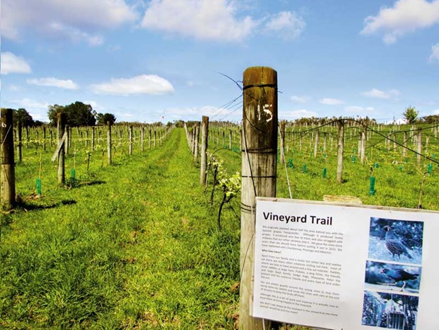
Whelan_11-Vineyard-Trail,-Ake-Ake-Vineyard.jpg

NEW ZEALAND’S FIRST VINEYARDS

Samuel, New Zealand’s first missionary, established a vineyard with more than 100 varieties of grapes at the mission settlement he founded at Kerikeri. He wrote in his journal of 1819 that he thought New Zealand’s climate and soils should be ‘favourable to the vine’.
British Consul, James Busby, arrived in the Bay of Islands in the 1830s. James was a wine expert, having trained in viticulture in France. His skills had already started the Australian wine growing industry. He had published books outlining directions for planting vineyards and making wine.
James lost no time in following in Samuel’s footsteps and was soon producing vintages at Waitangi. The French explorer Dumont d’Urville described one of James’ wines as ‘a light white wine... sparkling and delicious’. It has been suggested that this was chardonnay, James’ favourite tipple.

KERIKERI’S MOTORHOME-FRIENDLY VINEYARD

Alt TEXT HERE
Wine barrels outside the restaurant at Ake Ake
I had the same sort of thoughts while tasting some of Ake Ake Vineyard’s white wines at their cellar door. Tucked off the road to Waimate North (where Charles Darwin saw vines growing at the mission back in 1835), Ake Ake Vineyard and restaurant is well worth seeking out.
After sampling the chardonnay and pinot gris, I tried the pinot grigio, and decided that was the one for me. Meanwhile, Malcolm was trying the reds, finally choosing a bottle of chambourcin, made from red grapes that grow well in Northland. Then we were tempted by the port, which tasted like liquid Christmas cake—perfect for winter nights.
Alt TEXT HERE
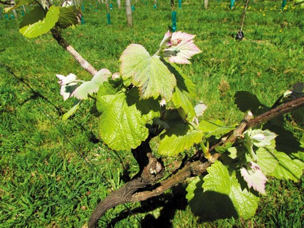
New vines growing at Ake Ake Vineyard
Hosts John and Aynsley Quenault purchased Ake Ake in 2004 and since then have been developing the boutique winery. John hails from the Channel Islands where his family had been wine merchants for five generations, while Aynsley is a New Zealander who spent a lot of time travelling by campervan on her OE.
The couple knew little about running a vineyard back in 2004 but researched winemaking at their local library and were soon winning medals with their vintages.
A few years ago, John and Aynsley decided to convert the vineyard to organic grape growing. They no longer use sprays, which means it is perfectly safe to immerse yourself among the vines on the vineyard trail.
Alt TEXT HERE
Special deals at the Kerikeri Old Packhouse Market
This is a self-guided walk that meanders along the rows of grapes, with signboards giving information along the way. We learned about the grape varieties, the winemaking process, and about all the creatures that call the vineyard home.
Ake Ake also has a restaurant, open for lunch and dinner, and locally sourced vegetables, meat, and seafood. During summer, meals are served on the deck outside, while in winter, diners can be eaten inside the cosy bistro.
The best thing of all, though, is that motorhomes are welcome overnight. Diners, or those purchasing wine from the vineyard, can stay in the parking area or make their way to a grassy paddock, where parking comes with views across rows of vines and nothing but rabbits, quail, pheasants, and the odd hedgehog for company.

Where else to find wine in Kerikeri

Alt TEXT HERE
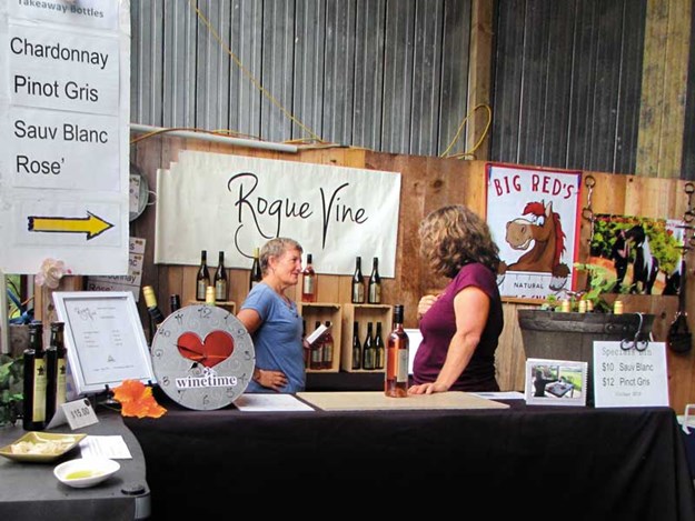
Wine for sale at the Old Packhouse Market
There are several other vineyards in the Kerikeri area, though none of the others offer overnight parking. However, Cottle Hill Vineyard is within easy walking distance of the Wagon Train RV Park. Cottle Hill is situated on the highest point in the area, so visitors can sit on the deck and admire beautiful views while enjoying their wine.
Another great wine tasting experience is at Kerikeri’s Old Packhouse Market, held every Saturday. Several local vineyards sell their produce here, and it’s an excellent place to sample wine as well as cheeses, bread, and pastries.
Alt TEXT HERE
The view from Cottle Hill Winery
We are always tempted by something when we visit here and often end up grabbing coffee and cake while listening to live music before heading back to the motorhome with our purchases. The NZMCA park at Rainbow Falls is a convenient place to stay.

Friday, 24 August 2018

Destination Dargaville

This is my latest article in Caravans, Motorhomes and Destinations Magazine


Dargaville sits on the banks of the Northern Wairoa River, close to kauri forests, the golden sands of Ripiro Beach, and the inlets and bays of the Kaipara Harbour, making it an ideal base for exploring.

The promise of some sunny winter days lured us to this small town on Northland’s west coast. The NZMCA recently opened a park at the old Thompson’s boatyard site beside the river and within easy walking distance of the town centre. As we pulled in, we noticed two interesting, old boat-builder’s sheds. These sheds date back to Dargaville’s early days and were used to build whaleboats that the explorer Ernest Shackleton took to Antarctica.
Ernest’s thank-you letter, displayed in Dargaville Museum, praises the craftsmanship of the boats.
Untitled-1.jpg

A brief history

Dargaville’s history is closely bound to the river. When the area was thickly forested, water transport provided the means to get from place to place. Later, as the forests began to be felled, kauri logs were loaded onto ships at Dargaville. The riverbanks still have many jetties and piles for boats to tie to, and there is a small boat harbour.
Politician and timber merchant Joseph Dargaville founded the town in 1872.
He realised the potential of the area and built a timber mill and trading post. Before long, he had added docks and tramways. Wanting to establish a town, rather than a bush settlement, he built shops and a church. Settlers began to flock in. The Central Hotel was established during this logging and ship building era, later advertising that it was close to the wharf and railway, and that telegrams were promptly attended to. The hotel still stands proudly by the river, its white paintwork gleaming as we strolled past.
After the kauri forests were felled, gum-diggers from Dalmatia settled in the area. Their heritage is celebrated by a statue in the town centre and also through exhibits and information at the Dargaville Museum. This is well worth a visit. As well as pioneering and gum-digging history, there is a maritime exhibition hall that showcases relics of ships wrecked on the Kaipara bar, and a Maori hall where there is a pre-European, 16-metre-long canoe hull, uncovered from the sands of the Pouto Peninsula.

KAURI COAST

It is ironic that the kauri, once felled in their thousands, are now treasured icons. Waipoua Forest, home to Tane Mahuta and other giant kauri trees, is around an hour’s drive north of Dargaville but closer is Trounson Kauri Park. James Trounson made the area a park in 1890. Since then, the park has expanded to 586 hectares and is a mainland island, home to not only kauri and other native trees but also kauri snails, bats, and brown kiwi.
The track at Trounson was a 40-minute loop, mostly on boardwalk, which helps protect the tree roots and prevent kauri die-back. Unfortunately, several of these marvellous trees have succumbed to the disease, though others towered above us. The bush was deep and green, full of spiky kiekie, neinei, and curling ferns, through which we heard the calling of tui.
Back on the main road, we called into Nelson’s Kaihu Kauri, a gallery of all things kauri.
Outside there was a large collection of swamp kauri logs and inside, an array of wooden arts and crafts, furniture, and kauri gum products. The gallery’s centrepiece is a 30-tonne kauri log dug from nearby peat swamps.
Untitled-1.jpg

Ripiro Beach

As a contrast to kauri forests, we turned towards the coast. Ripiro Beach, at 101km, is the longest drivable beach in New Zealand, stretching from Manganui Bluff to Pouto. It can be accessed at several places. Last time we were in Dargaville, we walked along the beach, leaving from Kai Iwi Lakes and going as far as Maunganui Bluff. This time, we went to
Baylys Beach, driving through the seaside settlement and onto the beach.
White sand stretched as far as the eye could see in both directions. High dunes bordered the beach, some had darker layers protruding. This was lignite, containing embedded kauri logs that were buried under the sand around 60,000 years ago. There were few people in the empty landscape and just one patient fisherman standing ankle-deep in the sea.We took a loop road inland to Mahuta Gap, south of Dargaville. This entrance to the beach was between massive sand dunes and is only suitable for four-wheel drive vehicles. We drove steeply downhill before coming to what was more stream than road. This section of beach was similar to Baylys but was wilder and seemed more remote. Finally, we came to Glinks Gully, another holiday settlement with quite a few baches—some traditional, others more modern.
Untitled-1.jpg
We then headed to the Pouto Peninsula, a 55km strip of mainly sand dunes that stretches from Dargaville to Pouto at the mouth of the Kaipara Harbour. It is quite narrow, varying from 4.5 to 14km in width, though the dunes are around 100 metres high, with the highest being more than 200 metres above sea level. From the road, we
could see down to the Northern
Wairoa River and across to the pyramid-shaped Tokatoka and the huge Maungaraho Rock.

GIANT KUMARA

Not all of the land surrounding Dargaville is sand; the area is known as New Zealand’s kumara-growing capital. As we drove back towards Dargaville, we saw a giant kumara at the roadside.
It was advertising the Kumara Box—an unusual attraction. Here, visitors can watch a show and learn everything there is to know about the vegetable. There is also a ‘train’ ride—a tractor towing brightly coloured carriages, made from oil-drums, around the farm.
Unfortunately, bookings are essential for the Kumara Box, so we had to pass on this occasion.
Dargaville Rail Tours is another unusual attraction. Trips in converted, self-drive golf carts leave from the town and, using the tracks of the old railway, pass through farmland to Tangowahine. A longer journey goes to Waiotira junction, taking between seven and eight hours (return). The same company runs 90-minute boat trips in a flat-bottomed boat called Daisy.
Kaipara Cruises occasionally host river trips in the harbour, leaving from Helensville, Dargaville, or Pahi. We took the Kewpie Too on a trip down the river from Dargaville to Pouto a couple of years ago. The commentary told us about the history and geography of the district before we disembarked at Pouto. From here, the tour was by bus to Pouto lighthouse, which was surprisingly small but atop a very steep sand dune.
For a small town, Dargaville has a lot to see and do. We’ll be back.
Untitled-1.jpg

TRAVEL INFORMATION

  • The NZMCA park is at 1 River Road, Dargaville, just across the Kaihu River bridge. There are several other motor camps, campervan parks, and Park Over Properties in Dargaville. Campervan sites are also available at the Dargaville Museum.
  • Dargaville Museum is at Harding Park. Hours: November–March 9am–5pm, April–October 9am–4pm. Find out more at dargavillemuseum.co.nz.
  • Trounson Park is off SH 12, 40km north of Dargaville. The easy loop walk takes 40 minutes. More information can be found on the DOC website. doc.govt.nz.
  • Nelson’s Kaihu Kauri is on SH 12 at Kaihu. Hours: 9am–5pm Monday–Saturday. Visit nelsonskaihukauri.co.nz.
  • The Kumara Box is at 503, Pouto Rd, Dargaville, kumarabox.co.nz.
  • Information about Dargaville Rail and River Tours can be found at portdargavillecruises.co.nz. Kaipara Cruises has more info at kaiparacruises.co.nz.

Saturday, 14 July 2018

Voyage of the Ika Roa


In Voyage of the Ika Roa, Heather Whelan relates the story of how she and then husband Tim built a boat and sailed it from England to New Zealand.  The couple had no boat-building or sailing experience but they set to and built Ika Roa, a catamaran.  Once afloat, their voyage took them to Spain and Portugal, then across the Atlantic.  By the time they arrived in the Caribbean, they were seasoned sailors.  While cruising the Pacific Heather became fascinated by Polynesian history and the islanders way of life.  Friendships among the cruising community and with locals enriched the journey.

NZ$ 29.99 plus postage ($5.50 within New Zealand)
>
If the buy now button doesn't work you can buy direct from me:  heatherwhelan2@gmail.com