A magical history tour
Wenderholm Regional Park has a fascinating history. The first people to enjoy the area were the Polynesian ancestors of Māori. Later, descendants of the Tainui and Moekaraka canoes explored the Puhoi and Waiwera Rivers, fished and built gardens. Little remains from those days except shell middens and place names – Wenderholm’s sandy spit is still called Te Akeake and the headland is Maungatauhoro. Wenderholm’s current name was bestowed on the area by a friend of Robert Graham, who bought the land in the 1840s, and means winter home in Swedish.
The Maungatauhoro Te Hikoi Track, starts near Couldrey House, an attractive, two-storey colonial house. Originally built by Robert Graham in 1857, it was added to by subsequent owners before becoming almost derelict. The Couldrey family restored the house during the 1960s and continued living there after selling Wenderholm to the Auckland Regional Authority in 1965. When they left in 1973, Couldrey House reverted to the council.
We left the quaint cottage garden and entered native bush beside a carved pouwhenua. The track leads fairly steeply up towards the cliffs of the headland and gives stunning views of the Te Akeake sand spit, the Puhoi River and the hills beyond. To the north are the headlands of Mahurangi Harbour and out to sea islands dot the ocean towards Kawau.
The sand spit is covered with gnarled pohutukawa, splashes of red visible from the track. These trees were planted over a century ago and form the largest grove of planted pohutukawa in the world.
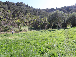
The native bush that covers the headland is a typical mix of kahikatea, manuka, nikau, rimu and tree fern and we were lured into it along the Couldrey House Track by large numbers of kererū and tui flying around the treetops. We were hoping to see a North Island robin, re-introduced to the park in 1999, but didn’t spot any.
After about 15 minutes, there’s an open area where the Couldrey House Track joins the Puhoi Track, which is an alternative way back to the Maungatauhoro Te Hikoi Track. This is another good lookout place with more great views – we could see past the Whangaparāoa Peninsula to Rangitoto Island.
Wanting to complete the headland track, we retraced our steps and then continued around to the southern side of Maungatauhoro. The track leads down to a sheltered little beach at Kokoru Bay, which looks across the river to Waiwera. Māori originally named this place Waiwerawera, very hot water, and it has been a thermal resort since the mid-1800s. Unfortunately, both the hot pools and the adjacent water-bottling facility have been closed and their future is uncertain.

Photo: Heather Whelan
The final part of the loop track runs close beside the estuary and past a turn-off, which leads to the road beside the Waiwera River Bridge. Then the track curves northward and runs parallel to Schischka Road to the car park near Couldrey House.


No comments:
Post a Comment